 THE FALSE PEAK OF TAAL VOLCANO
Taal Volcano is unique in the world. It’s a volcano—an active volcano. It has one large crater and that crater is filled with water making the crater a crater lake. On the lake is an island. It’s a tiny island but it is an island.
So far, it’s a description of a volcano with a single lake that has a tiny island.
Now, add this. This volcano is also in the middle of a lake. This lake, obviously, is larger than the entire volcano. That makes the volcano an island in this larger lake.
Now it’s complete. In the Philippines is a lake. On that lake is an island. That island is a volcano. On that island volcano is a smaller lake and on it, is another island. The smaller island is not a volcano but the island it’s on is. That volcano’s name is Taal.
Isn’t that unique?
Taal volcano (pronounced as two syllables: TA-AL; “TA” as in tar and “AL” as in alex) is considered to be the smallest active volcano in the world today. Signs of its activity will be visible if you take the boat tour and walk on the volcano island itself. You’ll spot fumaroles. A fumarole is a vent in the Earth’s surface from which steam and volcanic gases are emitted. (The Latin root of “fumarole” is fumus meaning smoke. In Spanish, “fumar” means to smoke.)
 The volcano is 60 kilometers (nearly 40 miles) southeast of the city of Manila proper. Metro Manila’s population creep has nearly halved that distance. For example, some of metro Manila’s affluent inhabitants live only 40 kilometers (25 miles) away from the volcano. For comparison, this is the distance between Chicago O’Hare airport to Chicago’s downtown area (the Loop).
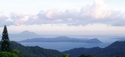
Its last major eruption occurred in 1965, or 44 years ago. Local inhabitants are willing to live within its proximity. There’s even a tourist resort based in the volcano island itself. With the exception of the fumarole photo, the other photos in this post were taken on 7 April 2009 from the same orientation—north facing southwest (approximately 210 degrees).
THE FALSE PEAK
To the casual observer, Taal’s peak seems obvious. Look at the first photo again (reproduced below). It’s a panoramic view of the entire volcano island. Can you see its peak?

The next photo below shows another view of the island from a higher elevation. Can you still see its peak? Is the peak on the left or right side of the island?

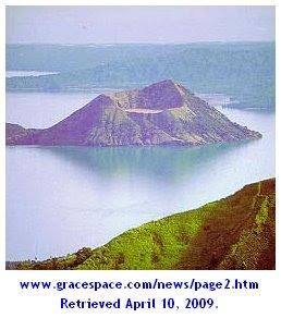
The next photo identifies the false peak. The peak that appears to be the volcano crater is an illusion. In this photo, the volcano’s actual crater is located between the left end and center of the island. The crater (which contains water and is a lake) is at ground level but the water level, naturally, is a little lower. The crater lake, therefore, is not visible in these photos. The illusion is explained at the end of this entry. The illusion, namely the false peak, has a name. It’s called Binintiang Malaki.

To enlarge any of these photos, simply click on it. To return to this page, click on the [left arrow] of your browser.
THE VISUAL ILLUSION EXPLAINED
If you review photos of Taal on sites around the web, you’ll realize how frequently this error occurs. The illusion mars what would otherwise be accurate captions of beautiful photos.
Here are several sites that fell prey to the illusion:
Back in the Islands

e-Philippines Adventure Travel and Destinations

TrekEarth The photographer-author unfortunately began his photo’s description by stating that “Taal Volcano (at the foreground, cone-shaped) has been called the smallest active volcano in the world.”

To enlarge any of these photos, simply click on it. To return to this page, click on the [left arrow] of your browser.
In each example above, it seems that the false peak was incorrectly identified as either the peak of the volcano or the volcano itself.
To understand why this happens, one must know that most trips to the volcano island originate from the north (frequently from the town of Talisay). Tagaytay City which sits on the ancient rim of the original volcano (before it blew itself apart) also lies to the north of Taal. If the face of a clock were superimposed on the area, Tagaytay City and Talisay would be at approximately 11 and 1 o’clock, respectively. Equally important, one must realize that most photographs are taken from those locations as well.
LOOK AT THESE IMAGES
Below is a satellite image of the area (courtesy of Google Maps). North is at 12 o’clock.

To enlarge any of these photos, simply click on it. To return to this page, click on the [left arrow] of your browser.
Below is a terrain image of the area (also courtesy of Google Maps). Again, north is at 12 o’clock.

Finally, below is the same terrain image rotated so that north is at about 6 o’clock. Note how the island is viewed. Note that the right side of the image shows the false peak of the volcano. The actual crater (i.e., the crater lake) sits betwen the left side and center of the image. Can you visualize it? If you can, then you understand why most observers and photos mistakenly think that the right side of the island is the volcano peak or even the volcano itself.

Several links to related photos, maps, and websites
Let’s not save the best for the last. This blog entry was taken from the website of the Astronomical League of the Philippines. It has better photos of fumaroles. It shows Binintiang Malaki (the false peak). Best of all, it has photos of Crater Lake and the tiny island on it!
This description of Taal came from the Public Information Office of the Jet Propulsion Laboratory (JPL) on November 18, 1994
This is an image of Taal volcano, near Manila on the island of Luzon in the Philippines. The black area in the center is Taal Lake, which nearly fills the 30-kilometer-diameter (18-mile) caldera. The caldera rim consists of deeply eroded hills and cliffs. The large island in Taal Lake, which itself contains a crater lake, is known as Volcano Island. The bright yellow patch on the southwest side of the island marks the site of an explosion crater that formed during a deadly eruption of Taal in 1965. The image was acquired by the space shuttle Endeavour on its 78th orbit in October 1994. The image shows an area approximately 56 kilometers by 112 kilometers (34 miles by 68 miles) that is centered at 14.0 degrees north latitude and 121.0 degrees east longitude. North is toward the upper right of the image.Click here to see the image.
Click here to read a comprehensive background on Taal. It appears that this blog entry identifies the correct crater although it doesn’t specify each photo to the geological feature.
If this entry helped observers understand the true topography of Taal Volcano, it has accomplished its purpose.

No comments:
Post a Comment