 IT SHOOK OUR PLANET
It happened on Christmas Day, 2004*. It was the largest earthquake in 40 years. It triggered a tsunami that killed over 200,000 people. It moved islands. And it was powerful enough to tickle our planet.
The blog entry about the Himalayas led me to better understand that deadly earthquake on Christmas Day 2004*. Remember that? It generated a killer tsunami that claimed about 230,000 lives.
(* It was 7 pm, U.S. Central time, on Christmas Day. It was 8 am, at where it occurred (local time), on December 26. Thanks to Malu for catching the original error. I still used Central time since I couldn’t think of a succinct subtitle for December 26.)According to the Global Seismographic Network (GSN), as quoted by about.com, at every spot on Earth, the ground was raised and lowered by at least a full centimeter. Surface waves traveled around our planet several times before dissipating. ... In effect, the Sumatra earthquake made the Earth ring ... like a hammer rings a bell!
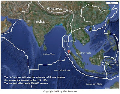
According to the US Geological Survey (USGS), the earthquake occurred near the junction of three tectonic plates: the Indian plate, the Burma plate, and the Australian plate. In the map above, the “A” marker in the center indicates the quake’s epicenter.
(You can enlarge any image by clicking on it. To return to this page, click on the back-arrow of your browser or press the Backspace key on your keyboard.)
 This blog entry discussed the origin of the Himalayas. It uncovered that the Himalayas are being formed by the relentless northward push of the Indian plate against the Asian landmass. Right alongside the Indian plate, is the much smaller Burma plate. Apparently, the Burma plate inches northwards too but at a different pace. (Willingham, 2005)
… the players in this megathrust, as geologists call it, were the Indian and Burma plates. For almost 200 years, these two plates have been pressing against one another, moving at the rate our fingernails grow-about 2.5 inches a year. … the Indian plate, after two centuries of pushing, finally slipped about 15 meters in the direction of Indonesia. In the process, it released the tension from butting up against the Burma plate, causing the Burma plate to bounce upward with violent consequences.Here, with appropriate credit, is a description of the effect the quake caused to our planet.
As a result of the springing Burma plate’s incredible energy release, the oceans gathered up the energy in the form of powerful tsunamis, surging waves that spread from Sumatra to India to East Africa, surging onto shores and wiping out everything in their paths before dragging thousands of people out to sea to their deaths. A fault beginning in the ocean floor opened up along a stretch of 745 miles, about the length of the state of California, and with the upward bounce of the Burma plate, islands and the mainland underwent some major changes.As I was drawing the boundaries of the plates, it became apparent that most of the seafloor is already etched with the boundaries. That, indeed, is powerful evidence of the existence of tectonic plates.
… most estimate that some small islands in the area shifted as much as 66 feet from their original positions, and the northwestern tip of Sumatra itself may have moved southwest about 118 feet. … The regional capital of Banda Aceh in western Sumatra was still under a few feet of water even after the waves receded, indicating that the city now lies below sea level.
And the Earth itself wobbled. Like a top when you touch it with your finger in the middle of its spin, the planet, whirling in its orbit, may have bobbled a bit when the temblor hit. Most experts agree that such a wobble is likely because of the huge amount of energy released. As for the redrawn maps, experts with hand-held global positioning system devices are attempting to reach some of the areas in question to obtain the new coordinates for the islands around the epicenter.
SUMATRAN EARTHQUAKE LITERALLY SHOOK THE PLANET
Plexus Encyclopedia of Medicine, Science, and Technology. Volume 2, Issue 39. January 17, 2005. Emily Willingham, Ph.D.
Where plates meet, there’s geological activity. In September 2007, for example, I blogged about the four strong earthquakes that hit Indonesia in a 24-hour span.
I find it so humbling to realize that the same movement that creates mountains also causes these gigantic events.

No comments:
Post a Comment