Saturday, April 25, 2009

Sumatran earthquake 2004 epicenter Indian Plate Burma Plate Tectonic PlateIT SHOOK OUR PLANET
It happened on Christmas Day, 2004*. It was the largest earthquake in 40 years. It triggered a tsunami that killed over 200,000 people. It moved islands. And it was powerful enough to tickle our planet.

The blog entry about the Himalayas led me to better understand that deadly earthquake on Christmas Day 2004*. Remember that? It generated a killer tsunami that claimed about 230,000 lives.
(* It was 7 pm, U.S. Central time, on Christmas Day. It was 8 am, at where it occurred (local time), on December 26. Thanks to Malu for catching the original error. I still used Central time since I couldn’t think of a succinct subtitle for December 26.)
According to the Global Seismographic Network (GSN), as quoted by about.com, at every spot on Earth, the ground was raised and lowered by at least a full centimeter. Surface waves traveled around our planet several times before dissipating. ... In effect, the Sumatra earthquake made the Earth ring ... like a hammer rings a bell!

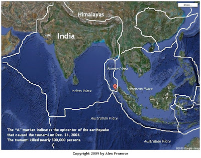
According to the US Geological Survey (USGS), the earthquake occurred near the junction of three tectonic plates: the Indian plate, the Burma plate, and the Australian plate. In the map above, the “A” marker in the center indicates the quake’s epicenter.

(You can enlarge any image by clicking on it. To return to this page, click on the back-arrow of your browser or press the Backspace key on your keyboard.)

Indian Plate Burma Plate Tectonic Plate BoundariesThis blog entry discussed the origin of the Himalayas. It uncovered that the Himalayas are being formed by the relentless northward push of the Indian plate against the Asian landmass. Right alongside the Indian plate, is the much smaller Burma plate. Apparently, the Burma plate inches northwards too but at a different pace. (Willingham, 2005)
… the players in this megathrust, as geologists call it, were the Indian and Burma plates. For almost 200 years, these two plates have been pressing against one another, moving at the rate our fingernails grow-about 2.5 inches a year. … the Indian plate, after two centuries of pushing, finally slipped about 15 meters in the direction of Indonesia. In the process, it released the tension from butting up against the Burma plate, causing the Burma plate to bounce upward with violent consequences.
Here, with appropriate credit, is a description of the effect the quake caused to our planet.
As a result of the springing Burma plate’s incredible energy release, the oceans gathered up the energy in the form of powerful tsunamis, surging waves that spread from Sumatra to India to East Africa, surging onto shores and wiping out everything in their paths before dragging thousands of people out to sea to their deaths. A fault beginning in the ocean floor opened up along a stretch of 745 miles, about the length of the state of California, and with the upward bounce of the Burma plate, islands and the mainland underwent some major changes.

… most estimate that some small islands in the area shifted as much as 66 feet from their original positions, and the northwestern tip of Sumatra itself may have moved southwest about 118 feet. … The regional capital of Banda Aceh in western Sumatra was still under a few feet of water even after the waves receded, indicating that the city now lies below sea level.

And the Earth itself wobbled. Like a top when you touch it with your finger in the middle of its spin, the planet, whirling in its orbit, may have bobbled a bit when the temblor hit. Most experts agree that such a wobble is likely because of the huge amount of energy released. As for the redrawn maps, experts with hand-held global positioning system devices are attempting to reach some of the areas in question to obtain the new coordinates for the islands around the epicenter.

SUMATRAN EARTHQUAKE LITERALLY SHOOK THE PLANET
Plexus Encyclopedia of Medicine, Science, and Technology. Volume 2, Issue 39. January 17, 2005. Emily Willingham, Ph.D.
As I was drawing the boundaries of the plates, it became apparent that most of the seafloor is already etched with the boundaries. That, indeed, is powerful evidence of the existence of tectonic plates.

Where plates meet, there’s geological activity. In September 2007, for example, I blogged about the four strong earthquakes that hit Indonesia in a 24-hour span.

I find it so humbling to realize that the same movement that creates mountains also causes these gigantic events.


Sphere: Related Content

Friday, April 24, 2009

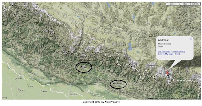
Kangtega HimalayasWHAT FORCES CREATED THE HIMALAYAN MOUNTAIN RANGE?

Everest, the tallest mountain in the world, towers nearly nearly nine kilometers. Everest is the most famous peak of the Himalayan mountain range. And that range, in turn, is one of the most celebrated features of our planet. What forces created it?

(You can enlarge any image by clicking on it. To return to this page, click on the back-arrow of your browser or press the Backspace key on your keyboard.)


An earlier post noted that four of the most accomplished climbers in the world began ascending Mt. Everest. What forces created Everest and the mountains around it?

The Collision of India and Asia
India did, or more precisely, the tectonic plate that India sits on, did. India’s plate has been pushing against the Asian landmass for the past 50 to 55 million years. The collision of two landmasses caused the earth to buckle up at these points of collision. The earth, at these points of collision, is literally being pushed up to form mountains.

(You can enlarge any image by clicking on it. To return to this page, click on the back-arrow of your browser or press the Backspace key on your keyboard.)


India Himalayas Everest Pronove tectonic movement

India Himalayas Everest Pronove tectonic movement

India Himalayas Everest Pronove tectonic movement

Plate Tectonics
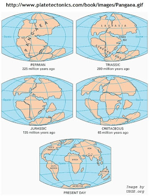
Early in the 20th century, a scientist named Wegener proposed that continents “drift.” Any world map will show the bulge on the eastern side of South America and the “hole” on the western side of Africa. The bulge appears to fit into the hole, doesn’t it? It appears that the two continents may have been one in the distant past. It appears, therefore, that South America and Africa separated. This observation among other, prompted Mr. Wegener to propose that continents drift. Later on, geologists confirmed that the uppermost layer of our planet moves around. Imagine the land that we see actually sits on a plate and that plate, in turn, rests on thick mud. The plate moves—albeit very slowly—and the land sitting on it naturally moves as well.

India Himalayas Everest Pronove tectonic movementIt’s such a radical notion, isn’t it? Land, after all, is the ground. Expressions such as “feet on the ground” or “grounded in reality” suggest a pragmatic let’s-be-real attitude. It also explains why earthquakes terrify us. After all, if the very ground that we believe is solid shakes, then what is solid?

Science believes that in the distant past, there existed only one landmass (that was named Pangaea). Over time—as in 225 million years—this single landmass separated into the seven continents we know today.

India Himalayas Everest Pronove tectonic movementIndia sits on its own plate and that plate is currently moving northeast at five centimeters per year (that’s two inches per year). According to the Paleomap Project, before India collided with Asia, India was moving at more than 15 centimeters per year. No modern plate moves that fast. (India’s northward race towards Asia may be something of a plate tectonic speed record!)

The Himalayas, therefore, were created by the collision of India with the rest of Asia. Tectonic forces, in other words, created the Himalayas.

Two things about this knowledge amaze me. First, these mountains originally constituted the seafloor. What was once, perhaps, eight kilometers below sea level are now eight kilometers above it. And second, these mountains—already the concentration of the tallest in the world—will continue to rise even more over the next millions of years.

Isn’t that something?


Sphere: Related Content
India Himalayas Everest Whittaker Viesturs Hahn Arnot National GeographicRETURN TO EVEREST

As reported by National Geographic, that’s what four of the most accomplished climbers in the world are doing right now. They’re ascending Mt. Everest—the tallest mountain in the world (above sea level.) It towers nearly 8,850 meters. That’s nearly nine kilometers tall! (In feet and miles, the mountain is about 29,030 feet or 5.5 miles tall!) Commercial airlines cruise at about 35,000 feet or 6.6 miles or nearly 11 kilometers.

(You can enlarge any image by clicking on it. To return to this page, click on the back-arrow of your browser or press the Backspace key on your keyboard.)


The following came from the National Geographic article.
The team began its ascent on March 30. Over the next two months, the climbers will make their way up the world’s tallest mountain in dangerous conditions, fighting hypothermia, altitude sickness, and sheer physical exhaustion to achieve something few can boast.

Mountaineer Peter Whittaker gathered the group as part of a quest to continue his family legacy; he is the nephew of legendary explorer Jim Whittaker, the first American to summit Mount Everest in 1963. Joining Whittaker is Ed Viesturs, a veteran mountaineer who has summitted all 14 of the world’s highest peaks without the aid of bottled oxygen; Dave Hahn, who is going for a record 11th Everest ascent; and Melissa Arnot, who is attempting to become the first female American to summit Everest without supplemental oxygen.
India Himalayas Everest Whittaker Viesturs Hahn Arnot National GeographicMt. Everest belongs to the Himalayan range. Have you ever wondered what force created these mountains? India did, or more precisely, the tectonic plate that India sits on, did.

Click here for an explanation.


Sphere: Related Content

Thursday, April 23, 2009

Russia Soyuz billionaire Simonyi Kazakhstan International Space Station ISSBILLIONAIRE’S SPACE ODYSSEY ENDS

So far, none of my friends seems convinced at my assertion that commercial space travel will be a reality in our lifetime, or at least by 2024. That’s only 15 years from now.

Clicking on the blog entry title will open a new window or tab. The International Space Station is shown in photo #1. This lead photo of the parachute landing is shown in photo #9.


A Russian Soyuz space capsule lands in Kazakhstan on April 8. The capsule carried a U.S. astronaut, a Russian cosmonaut and the billionaire space passenger Charles Simonyi from the International Space Station. Simonyi made his fortune at Microsoft by managing the development of the Microsoft Office suite.

This was Simonyi’s second trip to space. Simonyi was already the fifth space tourist in 2007 when he took his first trip.

I think I can now revise my estimate to 2019, just ten years from now. But doesn’t this all depend upon the definition of commercial space travel? What is it? What constitutes commercial space travel?


Sphere: Related Content

Friday, April 10, 2009

Taal VolcanoHOW TO GET TO TAAL VOLCANO FROM MANILA

In the preceding entry, I described the false peak of Taal Volcano. You might want to see it for yourself. The volcano is less than two-and-a-half hours away from metro Manila. It’s an easy day trip.

In this aerial photo, north is at 2 o’clock. The plane was traveling southwest, as if from 2 o’clock to 8 o’clock.

VISITING THE VOLCANO

From Manila, the most direct way to the lake is to take the South Luzon Expressway (SLEX) to the Sta. Rosa exit. Follow the signs to Tagaytay City. When you reach the T-junction, turn left. Follow this road for about five kilometers. Caution: this roadis known by two names: Tagaytay-Calamba Road or Tagaytay Ridge Road. Watch carefully on the lefthand side for the Tagaytay Elementary School. Once you see it, stop! Directly across it, on your righthand side, is Ligaya Drive. Turn right and drive down Ligaya Drive to the lake. You’ll come across a motley array of dwellings and new developments. At the bottom, follow the signs to Taal Lake Yacht Club (TLYC).

GETTING THERE

Ligaya Drive can be difficult to find, hence, this blog article. Ligaya Drive lies east of Tagaytay City proper. When you face the rotonda (there’s only one), you can only turn left or right. Turn left.

Ligaya Drive can be difficult to find because it is inconspicuous. Look for your first landmark. Look for it on the lefthand side. When you see it, stop! On the righthand side, or on the other side of the road, is Ligaya Drive!

Intersection Tagaytay Calamba Road Ligaya Drive Tagaytay Elementary School

The intersection of Tagaytay Ridge Road (also known as Tagaytay-Calamba Road) and Ligaya Drive looks like this.

Intersection Tagaytay Calamba Road Ligaya Drive

For emphasis, here’s a close-up of the same intersection.
Intersection Tagaytay Calamba Road Ligaya Drive

To enlarge any of these photos, simply click on it. To return to this page, click on the [left arrow] of your browser.

How will you know if you missed it? Well, you’ll have to turn around if you see Tagaytay Southridge. This is a prominent landmark on the lefthand side of the road. Seeing it indicates that you overlooked and missed Ligaya Drive.

Tagaytay Southridge Estates

Tagaytay Southridge Estates

If you overlook the intersection of Tayatay and Ligaya Drive, you will pass several structures that can also serve as landmarks to indicate that you should turn around and go back. A good example is the building of the Development Academy of the Philippines. However, none of them are as prominent as Southridge, hence Southridge was used.

If you discover that you missed it, you have to turn around. This time, the elusive Ligaya Drive will be on your lefthand side. On your righthand side, watch for this direction sign. Once you see it, stop!

Talisay Tagaytay

This sign is directly across Ligaya Drive. The direction sign indicates that Ligaya Drive will not only lead you to the lake but, if you continue along the drive, it will also lead you to the town of Talisay, which is five kilometers distant.

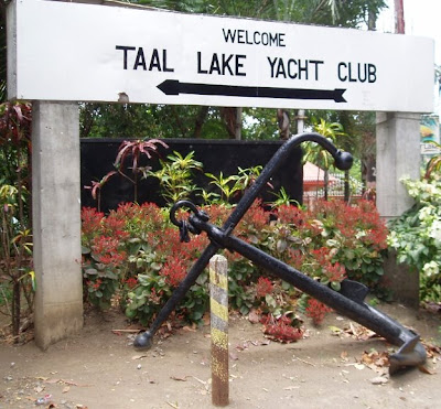
TAAL LAKE YACHT CLUB

You’ll be on Ligaya Drive for less than ten minutes. Follow the signs and go to the yacht club. We did and we rewarded ourselves with a satisfying lunch at the club. The air is fresh and the wind, strong. From there we could have rented a sailboat or taken the boat tour that would take us to the volcano island. According to the staff, the sailing season lasts from October to April. That’s when traffic is highest.

The photos below shows the marker for the yacht club at lake level. Apart from being a proper yacht club it’s also the home of the Philippine Hobie fleet. The Hobie Cat is one of the most popular small sailboats in the world.

Taal Lake Yacht Club

Taal Lake Yacht Club


Sphere: Related Content

Wednesday, April 8, 2009

Taal VolcanoTHE FALSE PEAK OF TAAL VOLCANO

Taal Volcano is unique in the world. It’s a volcano—an active volcano. It has one large crater and that crater is filled with water making the crater a crater lake. On the lake is an island. It’s a tiny island but it is an island.

So far, it’s a description of a volcano with a single lake that has a tiny island.

Now, add this. This volcano is also in the middle of a lake. This lake, obviously, is larger than the entire volcano. That makes the volcano an island in this larger lake.

Now it’s complete. In the Philippines is a lake. On that lake is an island. That island is a volcano. On that island volcano is a smaller lake and on it, is another island. The smaller island is not a volcano but the island it’s on is. That volcano’s name is Taal.

Isn’t that unique?


Taal volcano (pronounced as two syllables: TA-AL; “TA” as in tar and “AL” as in alex) is considered to be the smallest active volcano in the world today. Signs of its activity will be visible if you take the boat tour and walk on the volcano island itself. You’ll spot fumaroles. A fumarole is a vent in the Earth’s surface from which steam and volcanic gases are emitted. (The Latin root of “fumarole” is fumus meaning smoke. In Spanish, “fumar” means to smoke.)

fumarole, Taal Volcano The volcano is 60 kilometers (nearly 40 miles) southeast of the city of Manila proper. Metro Manila’s population creep has nearly halved that distance. For example, some of metro Manila’s affluent inhabitants live only 40 kilometers (25 miles) away from the volcano. For comparison, this is the distance between Chicago O’Hare airport to Chicago’s downtown area (the Loop).

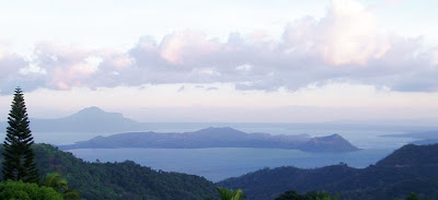
Its last major eruption occurred in 1965, or 44 years ago. Local inhabitants are willing to live within its proximity. There’s even a tourist resort based in the volcano island itself. With the exception of the fumarole photo, the other photos in this post were taken on 7 April 2009 from the same orientation—north facing southwest (approximately 210 degrees).

THE FALSE PEAK

To the casual observer, Taal’s peak seems obvious. Look at the first photo again (reproduced below). It’s a panoramic view of the entire volcano island. Can you see its peak?

Taal Volcano

The next photo below shows another view of the island from a higher elevation. Can you still see its peak? Is the peak on the left or right side of the island?

Taal Volcano

The next photo identifies the false peak. The peak that appears to be the volcano crater is an illusion. In this photo, the volcano’s actual crater is located between the left end and center of the island. The crater (which contains water and is a lake) is at ground level but the water level, naturally, is a little lower. The crater lake, therefore, is not visible in these photos. The illusion is explained at the end of this entry. The illusion, namely the false peak, has a name. It’s called Binintiang Malaki.

Taal Volcano

To enlarge any of these photos, simply click on it. To return to this page, click on the [left arrow] of your browser.

THE VISUAL ILLUSION EXPLAINED

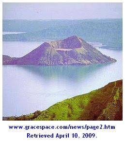
If you review photos of Taal on sites around the web, you’ll realize how frequently this error occurs. The illusion mars what would otherwise be accurate captions of beautiful photos.


Here are several sites that fell prey to the illusion:

Back in the Islands
Taal Volcano


e-Philippines Adventure Travel and Destinations
Taal Volcano


TrekEarth The photographer-author unfortunately began his photo’s description by stating that “Taal Volcano (at the foreground, cone-shaped) has been called the smallest active volcano in the world.”
Taal Volcano


To enlarge any of these photos, simply click on it. To return to this page, click on the [left arrow] of your browser.

In each example above, it seems that the false peak was incorrectly identified as either the peak of the volcano or the volcano itself.

To understand why this happens, one must know that most trips to the volcano island originate from the north (frequently from the town of Talisay). Tagaytay City which sits on the ancient rim of the original volcano (before it blew itself apart) also lies to the north of Taal. If the face of a clock were superimposed on the area, Tagaytay City and Talisay would be at approximately 11 and 1 o’clock, respectively. Equally important, one must realize that most photographs are taken from those locations as well.

LOOK AT THESE IMAGES

Below is a satellite image of the area (courtesy of Google Maps). North is at 12 o’clock.

Taal Volcano

To enlarge any of these photos, simply click on it. To return to this page, click on the [left arrow] of your browser.

Below is a terrain image of the area (also courtesy of Google Maps). Again, north is at 12 o’clock.

Taal Volcano

Finally, below is the same terrain image rotated so that north is at about 6 o’clock. Note how the island is viewed. Note that the right side of the image shows the false peak of the volcano. The actual crater (i.e., the crater lake) sits betwen the left side and center of the image. Can you visualize it? If you can, then you understand why most observers and photos mistakenly think that the right side of the island is the volcano peak or even the volcano itself.

Taal Volcano

Several links to related photos, maps, and websites

Let’s not save the best for the last. This blog entry was taken from the website of the Astronomical League of the Philippines. It has better photos of fumaroles. It shows Binintiang Malaki (the false peak). Best of all, it has photos of Crater Lake and the tiny island on it!

This description of Taal came from the Public Information Office of the Jet Propulsion Laboratory (JPL) on November 18, 1994
This is an image of Taal volcano, near Manila on the island of Luzon in the Philippines. The black area in the center is Taal Lake, which nearly fills the 30-kilometer-diameter (18-mile) caldera. The caldera rim consists of deeply eroded hills and cliffs. The large island in Taal Lake, which itself contains a crater lake, is known as Volcano Island. The bright yellow patch on the southwest side of the island marks the site of an explosion crater that formed during a deadly eruption of Taal in 1965. The image was acquired by the space shuttle Endeavour on its 78th orbit in October 1994. The image shows an area approximately 56 kilometers by 112 kilometers (34 miles by 68 miles) that is centered at 14.0 degrees north latitude and 121.0 degrees east longitude. North is toward the upper right of the image.
Click here to see the image.

Click here to read a comprehensive background on Taal. It appears that this blog entry identifies the correct crater although it doesn’t specify each photo to the geological feature.

If this entry helped observers understand the true topography of Taal Volcano, it has accomplished its purpose.


Sphere: Related Content