Showing posts with label Philippines. Show all posts

Thursday, July 30, 2009

kidney, bartter syndrome, pronove, NIHTHE PRONOVE-BARTTER SYNDROME

In 1960, a team of medical scientists working at the National Institutes of Health (NIH) identified a syndrome that affects the kidneys. A syndrome is “a group of symptoms that collectively indicate a disease, disorder, or other abnormal medical condition.”

The kidney is one of the body’s vital organs. A vital organ is one that performs an essential life function. Total failure of a vital organ will cause death. We have six vital organs. These are the brain, heart, lungs, liver, pancreas and kidneys.

We have two kidneys. Their function is “to keep the blood clean and chemically balanced. Wastes in the blood come from the normal breakdown of active tissues, such as muscles, and from food. The body uses food for energy and self-repairs. After the body has taken what it needs from food, wastes are sent to the blood. If the kidneys do not remove them, these wastes build up in the blood and damage the body.”

Persons suffering from this syndrome have kidneys that fail to keep the blood chemically balanced. They lose excessive amounts of potassium. It’s a relatively rare but serious condition.

I wrote this entry simply to thank a medical historian for clarifying the origin of the syndrome’s name.


Dear Mr. Enersen,

I am a nephew of the late Dr. Pacita Pronove-Irreverre. She was the lead author of the paper that first described the condition commonly known as the Bartter Syndrome. As you know, naming rights typically belong to the lead author.

In June 2008, I successfully persuaded Wikipedia to include my aunt’s name in the Wiki entry for the Bartter Syndrome. As you also probably know, Wikipedia is edited by the user community. It is a system that ensures rigorous verification. My primary evidence consisted of the relevant entry found at your website.

Apart from expressing gratitude, I want to corroborate your detailed explanation with a firsthand account of my late-aunt’s narration about the incident. This is more trivia than anything but as a historian you might enjoy it for the life it brings to your tale.

Several years before my aunt died and definitely before I knew about the syndrome’s existence, she told me the corroborating story. Auntie Pat had narrated it to her other nephews and nieces as well. (She and her doctor husband had no children themselves.) Auntie Pat told me that after she realized that injustice had been done, she looked Fred Bartter in the eye and Fred was unable to maintain eye contact. There was a smile on her face when she narrated that.

You can picture the times. She was a diminutive Asian woman in a field populated and dominated by white American men. She was still new to the U.S. The medical paper was published in 1960, only several years after she arrived. We can speculate why she partnered with Bartter. He has a Wiki entry and it reveals that he was the son of American missionaries who were stationed in the Philippines. So our aunt, a Filipina, had a common link with him. She must have felt that she had found a friend at her place of employment, the NIH.

She maintained her association with him even after the incident. They published a second paper together. She even had her sister accompany Fred and his wife back to Baguio to locate the graveyard of his parents. When she did this, I am unsure of—I will check with my cousins if they know whether this occurred before or after the incident. She was a gentle and generous soul so either time frame was possible.

Mr. Enersen, we are grateful to you for coming up with the idea for your website. It helped us add a satisfying footnote to both medical and our family’s history. I am sure that future generations of other people will appreciate and thank you for creating such a resource.

On behalf of our extended family, I thank you.

Sincerely,

Alex Pronove

P.S. Our family is preparing Dr. Pacita’s biographical sketch for Wikipedia as well.

Sphere: Related Content

Thursday, June 11, 2009

GMA Gloria Macapagal Arroyo Philippines PresidentTHE CASE OF THE DEFECTIVE POSTAGE STAMP
A new version of a familiar theme

The current President of the Philippines is arguably a crook. My sister sent me the following joke and I just had to share it. The joke is a version of a familiar theme.

PhilPost, the Philippine postal service, recently issued a stamp with a picture of President Arroyo. Her full name is Gloria Macapagal-Arroyo. The stamp was captioned “Gloria Forever.”

There was a problem however. The stamp would not stick to envelopes. This reportedly enraged the President who demanded a full investigation.

After a month of testing and spending 100 million pesos, the special Presidential commission presented their findings:
  • The stamp was in perfect condition.
  • There was nothing wrong with the adhesive.
  • People were just spitting on the wrong side.


Sphere: Related Content

Wednesday, April 8, 2009

Taal VolcanoTHE FALSE PEAK OF TAAL VOLCANO

Taal Volcano is unique in the world. It’s a volcano—an active volcano. It has one large crater and that crater is filled with water making the crater a crater lake. On the lake is an island. It’s a tiny island but it is an island.

So far, it’s a description of a volcano with a single lake that has a tiny island.

Now, add this. This volcano is also in the middle of a lake. This lake, obviously, is larger than the entire volcano. That makes the volcano an island in this larger lake.

Now it’s complete. In the Philippines is a lake. On that lake is an island. That island is a volcano. On that island volcano is a smaller lake and on it, is another island. The smaller island is not a volcano but the island it’s on is. That volcano’s name is Taal.

Isn’t that unique?


Taal volcano (pronounced as two syllables: TA-AL; “TA” as in tar and “AL” as in alex) is considered to be the smallest active volcano in the world today. Signs of its activity will be visible if you take the boat tour and walk on the volcano island itself. You’ll spot fumaroles. A fumarole is a vent in the Earth’s surface from which steam and volcanic gases are emitted. (The Latin root of “fumarole” is fumus meaning smoke. In Spanish, “fumar” means to smoke.)

fumarole, Taal Volcano The volcano is 60 kilometers (nearly 40 miles) southeast of the city of Manila proper. Metro Manila’s population creep has nearly halved that distance. For example, some of metro Manila’s affluent inhabitants live only 40 kilometers (25 miles) away from the volcano. For comparison, this is the distance between Chicago O’Hare airport to Chicago’s downtown area (the Loop).

Its last major eruption occurred in 1965, or 44 years ago. Local inhabitants are willing to live within its proximity. There’s even a tourist resort based in the volcano island itself. With the exception of the fumarole photo, the other photos in this post were taken on 7 April 2009 from the same orientation—north facing southwest (approximately 210 degrees).

THE FALSE PEAK

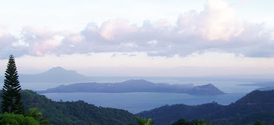
To the casual observer, Taal’s peak seems obvious. Look at the first photo again (reproduced below). It’s a panoramic view of the entire volcano island. Can you see its peak?

Taal Volcano

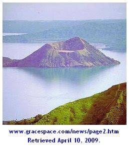
The next photo below shows another view of the island from a higher elevation. Can you still see its peak? Is the peak on the left or right side of the island?

Taal Volcano

The next photo identifies the false peak. The peak that appears to be the volcano crater is an illusion. In this photo, the volcano’s actual crater is located between the left end and center of the island. The crater (which contains water and is a lake) is at ground level but the water level, naturally, is a little lower. The crater lake, therefore, is not visible in these photos. The illusion is explained at the end of this entry. The illusion, namely the false peak, has a name. It’s called Binintiang Malaki.

Taal Volcano

To enlarge any of these photos, simply click on it. To return to this page, click on the [left arrow] of your browser.

THE VISUAL ILLUSION EXPLAINED

If you review photos of Taal on sites around the web, you’ll realize how frequently this error occurs. The illusion mars what would otherwise be accurate captions of beautiful photos.


Here are several sites that fell prey to the illusion:

Back in the Islands
Taal Volcano


e-Philippines Adventure Travel and Destinations
Taal Volcano


TrekEarth The photographer-author unfortunately began his photo’s description by stating that “Taal Volcano (at the foreground, cone-shaped) has been called the smallest active volcano in the world.”
Taal Volcano


To enlarge any of these photos, simply click on it. To return to this page, click on the [left arrow] of your browser.

In each example above, it seems that the false peak was incorrectly identified as either the peak of the volcano or the volcano itself.

To understand why this happens, one must know that most trips to the volcano island originate from the north (frequently from the town of Talisay). Tagaytay City which sits on the ancient rim of the original volcano (before it blew itself apart) also lies to the north of Taal. If the face of a clock were superimposed on the area, Tagaytay City and Talisay would be at approximately 11 and 1 o’clock, respectively. Equally important, one must realize that most photographs are taken from those locations as well.

LOOK AT THESE IMAGES

Below is a satellite image of the area (courtesy of Google Maps). North is at 12 o’clock.

Taal Volcano

To enlarge any of these photos, simply click on it. To return to this page, click on the [left arrow] of your browser.

Below is a terrain image of the area (also courtesy of Google Maps). Again, north is at 12 o’clock.

Taal Volcano

Finally, below is the same terrain image rotated so that north is at about 6 o’clock. Note how the island is viewed. Note that the right side of the image shows the false peak of the volcano. The actual crater (i.e., the crater lake) sits betwen the left side and center of the image. Can you visualize it? If you can, then you understand why most observers and photos mistakenly think that the right side of the island is the volcano peak or even the volcano itself.

Taal Volcano

Several links to related photos, maps, and websites

Let’s not save the best for the last. This blog entry was taken from the website of the Astronomical League of the Philippines. It has better photos of fumaroles. It shows Binintiang Malaki (the false peak). Best of all, it has photos of Crater Lake and the tiny island on it!

This description of Taal came from the Public Information Office of the Jet Propulsion Laboratory (JPL) on November 18, 1994
This is an image of Taal volcano, near Manila on the island of Luzon in the Philippines. The black area in the center is Taal Lake, which nearly fills the 30-kilometer-diameter (18-mile) caldera. The caldera rim consists of deeply eroded hills and cliffs. The large island in Taal Lake, which itself contains a crater lake, is known as Volcano Island. The bright yellow patch on the southwest side of the island marks the site of an explosion crater that formed during a deadly eruption of Taal in 1965. The image was acquired by the space shuttle Endeavour on its 78th orbit in October 1994. The image shows an area approximately 56 kilometers by 112 kilometers (34 miles by 68 miles) that is centered at 14.0 degrees north latitude and 121.0 degrees east longitude. North is toward the upper right of the image.
Click here to see the image.

Click here to read a comprehensive background on Taal. It appears that this blog entry identifies the correct crater although it doesn’t specify each photo to the geological feature.

If this entry helped observers understand the true topography of Taal Volcano, it has accomplished its purpose.


Sphere: Related Content

Tuesday, March 25, 2008

THE PHILIPPINE EAGLE: THE SECOND LARGEST AND MOST ENDANGERED RAPTOR IN THE WORLD

My father is an avid birdwatcher. It's too bad that he doesn't watch birds in the remote forests of the Philippines. If he did and was lucky, he might catch a glimpse of the Philippine eagle. The photos came from last month's issue of National Geographic Magazine. The February 2008 issue contained an article about the Philippine Eagle.

This raptor is the second largest and most endangered eagle in the world. Currently, this bird of prey is confirmed to exist in just four Philippine islands: Mindanao, Luzon, Leyte, and Samar. Scientists estimate that perhaps only a few hundred pairs remain in the world.


• You can click on any photo to enlarge it.
• Usted puede hacer clic en cualquier foto para ampliarlo.
• Вы можете нажать на любую фотографию, чтобы увеличить это.
• Ви клацання в фотографія до збільшуватися.

BACKGROUND

Let me quote from the Chicago Field Museum's website:

When the first humans arrived in the Philippines from adjacent Asia many thousands of years ago, they found an archipelago that was remarkably rich in natural resources. The seas were inhabited by the earth's most diverse marine communities on earth, providing an abundant source of food throughout the year. The land was covered almost entirely by rain forest that provided them with meat from wildlife, building materials, and seemingly everlasting supplies of clear, cool water.

Those natural resources have been squandered, so badly damaged by over-use, mismanagement, and greed that recovery is uncertain, and collapse seems to be a real possibility. The nation now faces stark alternatives: a decline from the biologically richest place on earth to environmental devastation, or recovery from the current brush with disaster to a point of stability. To understand the origin of this dramatic and terrible situation, we must begin with history, but must end with societal and personal choice.

Few countries in the world were originally more thoroughly covered by rain forest than the Philippines. Brazil has extensive savannah and brush; Indonesia has many dry islands; Kenya and Tanzania have only small patches of rain forest. A few hundred years ago, at least 95 percent of the Philippines was covered by rain forest; only a few patches of open woodland and seasonal forest, mostly on Luzon, broke the expanse of moist, verdant land.

By the time the Spanish arrived in the Philippines in the 16th century, scattered coastal areas had been cleared for agriculture and villages. The only domestic grazer was the water buffalo, and pastureland was very limited. Some forest had been cleared in the interior as well—particularly the terraced rice lands of the central cordillera mountain range of northern Luzon—but most coastal areas and the richest of the lowlands remained completely forested, broken only by the occasional cultivated clearings. By 1600, the human population of the Philippines probably numbered about 500,000, and old-growth rain forest over 90 percent of the land, home to thousands of plant and animal species interacting in the web of life that sustained the human population.

THIS MAJESTIC CARNIVORE

From National Geographic's website:

With a wingspan of two meters (seven feet) and a weight of up to 6.5 kilograms (15 pounds), the species casts an impressive shadow as it soars through its rain forest home. Its long tail helps it skillfully maneuver while hunting for its elusive prey, like flying lemurs or palm civets.

Known for its large, deep bill and spiky crest, the Philippine eagle is arguably the most majestic creature in the rain forest. Its blue-gray eyes, unique among raptors, add to its striking appearance. The bird’s call is a loud, high-pitched whistle. Both female and male eagles display their impressive crests when on alert. An eagle twists its head to change its visual perspective and determine an object’s size and distance.

A breeding pair of eagles requires from 40 to 80 square kilometers (25 to 50 square miles) of rain forest to survive. The word "raptor" comes from the Latin root that means "to seize and carry away." Any bird that kills with its feet is a raptor. While they often catch prey in midair, those nesting in large trees in lowland areas search for prey on the ground. Eagles hunt a variety of animals, ranging in size from small bats to 14-kilogram (30-pound) deer. The most common prey is the flying lemur, an arboreal mammal with webbed feet and claws. Other meals of choice include palm civets, flying squirrels, snakes, rats, and birds.

For decades the bird was known as the monkey-eating eagle. A presidential proclamation renamed it the Philippine eagle in 1978, in part to promote national pride in the magnificent endangered bird. In 1995 the Philippine eagle replaced the maya as the national bird.

VIDEO

This video shows an eagle hunting in flight.


DO YOU WANT TO HELP?

Click here: The Philippine Eagle Foundation

Here's one final whimsical look at this magnificent animal.


Sphere: Related Content

Thursday, September 13, 2007

FOUR EARTHQUAKES HIT INDONESIA IN THE PAST
24 HOURS

September 12 to 13

First one - Wed. evening - magnitude 8.4
2nd - Thu. morning - magnitude 7.8
3rd - Thu. morning - magnitude 7.1
4th - Thu. afternoon - magnitude 6.2

Indonesia is a "wide" country that runs east to west. It spans three time zones and is, respectively, 12, 13, and 14 hours ahead of Chicago. The Philippines is a "tall" country and spans only one time zone. It is 13 hours ahead of Chicago. I'm writing this on Thu. morning in Chicago so the first earthquake occurred yesterday morning, Chicago time. In other words, these four events occurred in a span of 24 hours, from yesterday morning to this morning.

Richter Scale - Effects - Frequency of Occurrence

6.0 to 6.9 - Destructive within 50-mile radius - 120 per year
7.0 to 7.9 - Serious damage within 100-mile radius - 18 per year
8.0 to 8.9 - Serious damage within 200-mile radius - 1 per year

Click here for a map of these earthquakes.


Click here for the CNN news report of these earthquakes.

Click here for an explanation of the Richter Scale.


Sphere: Related Content

Sunday, August 12, 2007

BUSINESS CONTINUITY

One step beyond Disaster Recovery

I recently advised a medium-sized commercial bank in the Philippines about a stalled project to create a business continuity solution.

Financial institutions in the Philippines do not face equivalent data integrity and safety requirements as they do here in the U.S. Still, management knew that they had to improve their IT capabilities. Their primary data center is located in their head office and it’s vulnerability surfaced at every coup attempt.

They learned about me from another client. Click
here for that story.

The bank was trying to install an EMC Asynchronous SRDF solution.

I briefly worked for EMC U.S.A. as a systems engineer. I’m familiar with the product line and the subject of disaster recovery & business continuity in general.

Disaster Recovery (DR) aptly describes the process of recovering from a disaster.

DR can be illustrated with the knowledge that all hard drives crash. It’s not a question of “if,” but a question of “when.” When the drives of a “production box” crash, business grinds to a halt unless and until the data can be restored and the server restarted. The process of restoring the data and restarting the server is disaster recovery.
A “production box” is tech-speak for a computer server that’s serving a live network.
Operations can grind to a halt for any number of reasons. Fire, a software crash, human error, network failure, and a power blackout are common culprits.

DR planning begins by defining the acceptable minimum values of two factors. The first is called the Recovery Time Objective (RTO) and the second is the Recovery Point Objective (RPO).
RTO is the amount of time you require to recover your lost or damaged data in order to become operational again. Can your business tolerate being down for several days or several hours? Whether it’s days or hours, this figure is your RTO.
RPO, on the other hand, is the amount of data accumulated over time that you can tolerate losing. Can your business afford to lose a day’s worth of data? If so, then your data must be backed up on a daily basis. A retail operation, like a supermarket, that logs hundreds or thousands of transactions a day may require several backups made during the course of the day.
“Business Continuity” (BC) extends the scope of preparation, plans, and resources past DR. Those two factors, RTO and RPO, figure into this as well.
BC’s goal is to ensure the business will be able to continue operating through crises and disasters. Accomplishing that requires going beyond the processes and equipment for restoring data and replacing equipment. Indeed, BC refers to making plans and preparing resources that, among other things, will prevent the loss of data. It refers to advance preparation in order to cope with the unexpected.

A good BC plan has:
  1. identified the most likely disaster scenarios and their impact on the business;
  2. determined the “mission-critical,” important, and less-important processes, systems, and services of the company;
  3. established its priorities for supporting the mission-critical components;
  4. developed and implemented the most redundant and fault-tolerant system possible within its budget;
  5. several alternate strategies
  6. taught and regularly practice the plan with its people; and
  7. the continuing support of senior management.
“Mission-critical” is tech-speak for the most important processes, systems, and services that a business must have in order to fulfill its mission. What is a mission? For a hospital, it could be the 24/7 availability of patient information.

“Redundant” is tech-speak for a backup that can temporarily take the place of a failed primary system.

“Fault-tolerant” is tech-speak for the characteristic of being able to withstand glitches.

Certain industries and companies require uninterrupted IT services. For them, BC is mandatory. The airline industry and financial institutions are examples. The financial sector, in fact, has to follow stringent guidelines for protecting and maintaining the security of its data. These companies must have minimal downtime. How minimal?
A calendar year has 8,760 hours. To give you an idea of the pressure to perform, consider that a 99.9% uptime is “only” equivalent to 8,751 hours.
Imagine the trouble a bank would face if it's nine non-operational hours occurred on the 15th. Employees would not receive their pay.
It turns out that a 99.99% uptime is required to stay operational 8,759 hours of the year! That’s still one hour short of the goal!
When the availability or integrity of data is compromised for any reason, businesses risk losing revenue and market share, experiencing decreased productivity, damaging their reputation, eroding their customers’ loyalty, and, in certain industries, being penalized for failing to comply with mandated regulations.

I enjoy BC planning because it's an activity that can incorporate numerous improvements for a little or no additional cost. It's a rare opportunity to deliver a lot of added value beyond the client's initial expectations.

There are several ways to go with DR and BC. You can create it in-house or outsource some or all of its aspects.

I'll cover both but the next entry will focus on the offerings of two established players in the field of storage, DR, and BC. These are the two
I’m familiar with, EMC and NetApp.


Sphere: Related Content

Sunday, July 29, 2007

DISASTER RECOVERY FROM A COUP D'ETAT

Business continuity in action!

Four years ago this month, a disaster recovery solution we created proved its worth. It saved our client, an international property consulting firm, from tanking after an attempted coup d’etat in 2003.

The Philippines has been wracked by four or five coup attempts in the last ten years. That averages to one every 24 months!

The renegades, 300 heavily armed soldiers and their leaders, barricaded themselves in several buildings in Makati’s business district. The standoff lasted for 19 hours before they surrendered. During the crisis, authorities turned off the power grid that served the contested area. My client’s office was within that grid. After it was over, her staff returned to a ransacked office.

Other companies in her building were not so fortunate. In fact, my client was the only one who was able to restore her data and resume operations as if nothing had happened.

About half of her neighbors—branch offices of large companies as well as individual businesses—did not back up at all. As for the other half, the IT manager kept their backup data offsite by bringing the media home. I learned that many of the ones who backed up discovered that their backups were too old or could not be restored.
The latter didn’t surprise me. In smaller shops, many IT administrators diligently back up their data but neglect to regularly test the media’s integrity by doing test restores. Back in the days when I was a network engineer, I was installing Citrix in a 25-desktop network. They had two Windows NT servers and had always been using Windows NT’s built-in backup utility. I knew about that utility’s notorious reputation so I challenged them to restore the data (prior to my continuing my work). Their office manager, who doubled as the IT administrator, pulled out seven tape cartridges. One by one, she tried to restore the contents of each tape. And one by one, she discovered they were empty. In fact, if I recall correctly, the MS-DOS directory listing revealed one empty folder in each tape. That’s how we sold a lot of ARCserve software back then!
As for my client, months earlier, we added additional storage. I persuaded them to configure it to do double-duty as a disaster recovery system. The hardware was kept in a cabinet closet (literally) down the hall. The system consisted of a NetApp NAS (Network Attached Storage) appliance and Symantec’s Backup Exec (System Recovery version).

I was back in the U.S. when this happened and I was able to talk them through the procedure. They were up and running by the end of the day!


Sphere: Related Content